Weather Alert in Kentucky
Winter Weather Advisory issued February 21 at 11:11PM EST until February 23 at 6:00PM EST by NWS Jackson KY
AREAS AFFECTED: Harlan; Floyd; Knott; Perry; Letcher; Martin; Pike
DESCRIPTION: * WHAT...Rounds of snow showers are expected, resulting in event total snow accumulations of 1 to 2 inches for most locations, with locally higher amounts possible. Accumulations up to 5 inches are possible above 3000 feet elevation. * WHERE...Portions of northeast and southeast Kentucky. * WHEN...From 11 AM Sunday to 6 PM EST Monday. * IMPACTS...Plan on slippery road conditions and significant differences in road conditions at times. The hazardous conditions could impact the Monday morning and evening commutes. * ADDITIONAL DETAILS...Wind gusts as high as 20 to 30 mph in the heavier snow showers, combined with the falling snow may cause sudden visibility reductions, mainly during the daytime hours Sunday and Monday.
INSTRUCTION: Slow down and use caution while traveling. The latest road conditions for Kentucky can be found by visiting https://goky.ky.gov.
Want more detail? Get the Complete 7 Day and Night Detailed Forecast!
Current U.S. National Radar--Current
The Current National Weather Radar is shown below with a UTC Time (subtract 5 hours from UTC to get Eastern Time).

National Weather Forecast--Current
The Current National Weather Forecast and National Weather Map are shown below.

National Weather Forecast for Tomorrow
Tomorrow National Weather Forecast and Tomorrow National Weather Map are show below.

North America Water Vapor (Moisture)
This map shows recent moisture content over North America. Bright and colored areas show high moisture (ie, clouds); brown indicates very little moisture present; black indicates no moisture.

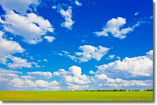
Weather Topic: What are Cumulus Clouds?
Home - Education - Cloud Types - Cumulus Clouds
 Next Topic: Drizzle
Cumulus clouds are fluffy and textured with rounded tops, and
may have flat bottoms. The border of a cumulus cloud
is clearly defined, and can have the appearance of cotton or cauliflower.
Cumulus clouds form at low altitudes (rarely above 2 km) but can grow very tall,
becoming cumulus congestus and possibly the even taller cumulonimbus clouds.
When cumulus clouds become taller, they have a greater chance of producing precipitation.
Next Topic: Drizzle
Weather Topic: What is Evaporation?
Home - Education - Precipitation - Evaporation
 Next Topic: Fog
Evaporation is the process which returns water from the earth
back to the atmosphere, and is another crucial process in the water cycle.
Evaporation is the transformation of liquid into gas, and it happens because
molecules are excited by the application of energy and turn into vapor.
In order for water to evaporate it has to be on the surface of a body of water.
Next Topic: Fog
Current conditions powered by WeatherAPI.com


