Weather Alert in Minnesota
Winter Weather Advisory issued February 17 at 1:00PM CST until February 19 at 12:00AM CST by NWS Duluth MN
AREAS AFFECTED: South Cass; Crow Wing; South Aitkin
DESCRIPTION: * WHAT...Mixed precipitation expected. Total snow accumulations between 1 and 3 inches and ice accumulations around one tenth of an inch. Winds gusting as high as 40 mph. * WHERE...Crow Wing, South Aitkin, and South Cass Counties. This includes the Tribal Lands of the Mille Lacs Band, East Lake area. * WHEN...From 6 PM this evening to midnight CST Wednesday Night. * IMPACTS...Plan on slippery road conditions. The hazardous conditions could impact the Wednesday morning and evening commutes. * ADDITIONAL DETAILS...Freezing rain chances are highest tonight into Wednesday morning. Light snowfall with the highest totals around 3 inches are forecast for in the northern third of each area Wednesday.
INSTRUCTION: Slow down and use caution while traveling. Call 511 or visit www.511mn.org for Minnesota road information.
Want more detail? Get the Complete 7 Day and Night Detailed Forecast!
Current U.S. National Radar--Current
The Current National Weather Radar is shown below with a UTC Time (subtract 5 hours from UTC to get Eastern Time).

National Weather Forecast--Current
The Current National Weather Forecast and National Weather Map are shown below.

National Weather Forecast for Tomorrow
Tomorrow National Weather Forecast and Tomorrow National Weather Map are show below.

North America Water Vapor (Moisture)
This map shows recent moisture content over North America. Bright and colored areas show high moisture (ie, clouds); brown indicates very little moisture present; black indicates no moisture.

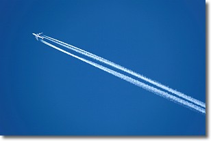
Weather Topic: What are Contrails?
Home - Education - Cloud Types - Contrails
 Next Topic: Cumulonimbus Clouds
A contrail is an artificial cloud, created by the passing of an
aircraft.
Contrails form because water vapor in the exhaust of aircraft engines is suspended
in the air under certain temperatures and humidity conditions. These contrails
are called exhaust contrails.
Another type of contrail can form due to a temporary reduction in air pressure
moving over the plane's surface, causing condensation.
These are called aerodynamic contrails.
When you can see your breath on a cold day, it is also because of condensation.
The reason contrails last longer than the condensation from your breath is
because the water in contrails freezes into ice particles.
Next Topic: Cumulonimbus Clouds
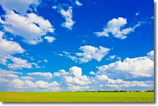
Weather Topic: What are Cumulus Clouds?
Home - Education - Cloud Types - Cumulus Clouds
 Next Topic: Drizzle
Cumulus clouds are fluffy and textured with rounded tops, and
may have flat bottoms. The border of a cumulus cloud
is clearly defined, and can have the appearance of cotton or cauliflower.
Cumulus clouds form at low altitudes (rarely above 2 km) but can grow very tall,
becoming cumulus congestus and possibly the even taller cumulonimbus clouds.
When cumulus clouds become taller, they have a greater chance of producing precipitation.
Next Topic: Drizzle
Current conditions powered by WeatherAPI.com


