Weather Alert in Oregon
Winter Storm Warning issued February 18 at 4:58AM PST until February 19 at 10:00AM PST by NWS Medford OR
AREAS AFFECTED: Jackson County
DESCRIPTION: * WHAT...For the Winter Weather Advisory below 2000 ft, snow expected. Additional snow accumulations of 1 to 3 inches. For the Winter Storm Warning above 2000 ft, heavy snow expected. Total snow accumulations 3 to 6 inches, except up to 10 inches above 2500 feet. * WHERE...For the Winter Weather Advisory below 2000 ft, this includes Medford, Ashland, Gold Hill, Jacksonville, Applegate, Shady Cove and Eagle Point. This also includes portions of I-5 and Highways 140, 238, 62 and 234. For the Winter Storm Warning, this includes Prospect and Butte Falls. This also includes portions of I-5, Highways 140, 238, 62 and 227, and includes Jacksonville Hill on State Highway 238 at 2150 ft. * WHEN...Until 10 AM PST Thursday. * IMPACTS...Travel may be difficult and delays in your commute. The hazardous conditions could impact the Wednesday morning and evening commutes. * ADDITIONAL DETAILS...Another round of snowfall is expected tonight into Thursday. Visit weather.gov/mfr/winter for additional snow probabilities
INSTRUCTION: If you must travel, keep an extra flashlight, food, and water in your vehicle in case of an emergency. Call 511 or visit tripcheck.com for road information. Slow down and use caution while traveling. Call 511 or visit tripcheck.com for road information.
Want more detail? Get the Complete 7 Day and Night Detailed Forecast!
Current U.S. National Radar--Current
The Current National Weather Radar is shown below with a UTC Time (subtract 5 hours from UTC to get Eastern Time).

National Weather Forecast--Current
The Current National Weather Forecast and National Weather Map are shown below.

National Weather Forecast for Tomorrow
Tomorrow National Weather Forecast and Tomorrow National Weather Map are show below.

North America Water Vapor (Moisture)
This map shows recent moisture content over North America. Bright and colored areas show high moisture (ie, clouds); brown indicates very little moisture present; black indicates no moisture.

Weather Topic: What are Cirrus Clouds?
Home - Education - Cloud Types - Cirrus Clouds
 Next Topic: Condensation
Cirrus clouds are high-level clouds that occur above 20,000 feet
and are composed mainly of ice crystals.
They are thin and wispy in appearance.
What do they indicate?
They are often the first sign of an approaching storm.
Next Topic: Condensation
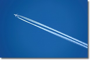
Weather Topic: What are Contrails?
Home - Education - Cloud Types - Contrails
 Next Topic: Cumulonimbus Clouds
A contrail is an artificial cloud, created by the passing of an
aircraft.
Contrails form because water vapor in the exhaust of aircraft engines is suspended
in the air under certain temperatures and humidity conditions. These contrails
are called exhaust contrails.
Another type of contrail can form due to a temporary reduction in air pressure
moving over the plane's surface, causing condensation.
These are called aerodynamic contrails.
When you can see your breath on a cold day, it is also because of condensation.
The reason contrails last longer than the condensation from your breath is
because the water in contrails freezes into ice particles.
Next Topic: Cumulonimbus Clouds
Current conditions powered by WeatherAPI.com


