Weather Alert in Minnesota
Winter Weather Advisory issued April 1 at 2:20PM CDT until April 2 at 7:00PM CDT by NWS Twin Cities/Chanhassen MN
AREAS AFFECTED: Douglas; Todd; Morrison; Mille Lacs; Kanabec; Stevens; Pope; Stearns; Benton; Lac Qui Parle; Swift; Chippewa; Kandiyohi; Meeker; Yellow Medicine
DESCRIPTION: ...MESSY SPRING SYSTEM BRINGS FREEZING RAIN, SLEET, AND SNOWTO PORTIONS OF MINNESOTA AND WISCONSIN TONIGHT THROUGH THURSDAY... .A powerful spring weather system will bring widespread precipitation to the region beginning tonight and lingering through Thursday, with areas of wet snow, freezing rain, sleet, and rain all expected depending on timing and location. Western and central Minnesota will experience mainly slushy wet snow with accumulations of 2 to 4 inches, meanwhile rain is favored in southern and southeastern Minnesota. In between the snow and rain, a messy wintry mix of sleet and freezing rain will result in ice accumulations and slippery travel. There is still a moderate degree of uncertainty regarding ice accumulation amounts, due to temperatures being very close to freezing and a fluctuation of only a degree or two likely having a large impact on final amounts. The greatest impacts from icing and freezing rain will occur over western Wisconsin and portions of east-central to southwestern Minnesota, with accumulations up to a quarter inch in Minnesota and a few tenths of an inch in Wisconsin. Power outages are possible due to icing of power lines in addition to gusty winds, and slippery to impossible travel will occur where ice accumulates. Slow travel from wet slushy snow is expected in western and central Minnesota. * WHAT...Mixed precipitation expected. Total snow accumulations between 1 and 3 inches, sleet accumulations around one half of an inch, and ice accumulations up to a tenth of an inch. * WHERE...Benton, Kandiyohi, Meeker, Morrison, Stearns, Todd, Kanabec, Mille Lacs, Chippewa, Douglas, Lac Qui Parle, Pope, Stevens, Swift, and Yellow Medicine Counties. * WHEN...From 10 PM this evening to 7 PM CDT Thursday. * IMPACTS...Plan on slippery road conditions. The hazardous conditions will impact the Thursday morning and evening commutes.
INSTRUCTION: Slow down and use caution while traveling. Call 5 1 1 or visit 511mn.org for road conditions. Be prepared for slippery roads. Slow down and use caution while driving. If you are going outside, watch your first few steps taken on stairs, sidewalks, and driveways. These surfaces could be icy and slippery, increasing your risk of a fall and injury.
Want more detail? Get the Complete 7 Day and Night Detailed Forecast!
Current U.S. National Radar--Current
The Current National Weather Radar is shown below with a UTC Time (subtract 5 hours from UTC to get Eastern Time).

National Weather Forecast--Current
The Current National Weather Forecast and National Weather Map are shown below.

National Weather Forecast for Tomorrow
Tomorrow National Weather Forecast and Tomorrow National Weather Map are show below.

North America Water Vapor (Moisture)
This map shows recent moisture content over North America. Bright and colored areas show high moisture (ie, clouds); brown indicates very little moisture present; black indicates no moisture.

Weather Topic: What is Rain?
Home - Education - Precipitation - Rain
 Next Topic: Shelf Clouds
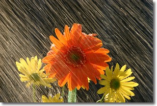
Precipitation in the form of water droplets is called rain.
Rain generally has a tendency to fall with less intensity over a greater period
of time, and when rainfall is more severe it is usually less sustained.
Rain is the most common form of precipitation and happens with greater frequency
depending on the season and regional influences. Cities have been shown to have
an observable effect on rainfall, due to an effect called the urban heat island.
Compared to upwind, monthly rainfall between twenty and forty miles downwind of
cities is 30% greater.
Next Topic: Shelf Clouds
Weather Topic: What is Sleet?
Home - Education - Precipitation - Sleet
 Next Topic: Snow
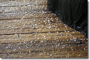
Sleet is a form of precipitation in which small ice pellets are the primary
components. These ice pellets are smaller and more translucent than hailstones,
and harder than graupel. Sleet is caused by specific atmospheric conditions and
therefore typically doesn't last for extended periods of time.
The condition which leads to sleet formation requires a warmer body of air to be
wedged in between two sub-freezing bodies of air. When snow falls through a warmer
layer of air it melts, and as it falls through the next sub-freezing body of air
it freezes again, forming ice pellets known as sleet. In some cases, water
droplets don't have time to freeze before reaching the surface and the result is
freezing rain.
Next Topic: Snow
Current conditions powered by WeatherAPI.com


