Weather Alert in California
Fire Weather Watch issued June 29 at 11:21PM PDT until July 1 at 11:00PM PDT by NWS Eureka CA
AREAS AFFECTED: Lower Middle Klamath; Hoopa; Van Duzen/Mad River; W Mendocino NF/E Mendocino Unit; Trinity
DESCRIPTION: ...SCATTERED DRY LIGHTNING IS LIKELY MONDAY AND TUESDAY AFTERNOON ACROSS THE INTERIOR MOUNTAINS... .A pulse of moisture moving up the Central Valley combined with very hot and dry surface conditions and moderate easterly winds will combine to create scattered dry thunderstorms over the interior mountains. Any storms that do form will likely produce wetting rain in the cores but lightning is possible far from these cores in areas that will remain dry. Stroms Monday are most likely over Northern Trinity and Interior Humboldt with moderate movement towards the coast. Stroms Tuesday will be more stationary and are most likely to form over southern Trinity and Northern Mendocino Counties. * THUNDERSTORMS...Scattered dry thunderstorms are likely (25% chance) Monday Tuesday afternoons. There is a slight chance of isolated thundersotrms overnight Monday into Tuesday. * OUTFLOW WINDS...Gusty and erratic outflow winds are possible up to 50 mph. * IMPACTS...any fires that develop will likely spread rapidly. Outdoor burning is not recommended.
INSTRUCTION: A Red Flag Warning means that critical fire weather conditions are either occurring now, or will shortly. A combination of strong winds, low relative humidity, and warm temperatures can contribute to extreme fire behavior. A Fire Weather Watch means that critical fire weather conditions are forecast to occur. Listen for later forecasts and possible Red Flag Warnings.
Want more detail? Get the Complete 7 Day and Night Detailed Forecast!
Current U.S. National Radar--Current
The Current National Weather Radar is shown below with a UTC Time (subtract 5 hours from UTC to get Eastern Time).

National Weather Forecast--Current
The Current National Weather Forecast and National Weather Map are shown below.

National Weather Forecast for Tomorrow
Tomorrow National Weather Forecast and Tomorrow National Weather Map are show below.

North America Water Vapor (Moisture)
This map shows recent moisture content over North America. Bright and colored areas show high moisture (ie, clouds); brown indicates very little moisture present; black indicates no moisture.

Weather Topic: What are Fractus Clouds?
Home - Education - Cloud Types - Fractus Clouds
 Next Topic: Freezing Rain
A fractus cloud (scud) is a fragmented, tattered cloud which has
likely been sheared off of another cloud. They are accessory clouds, meaning they
develop from parent clouds, and are named in a way which describes the original
cloud which contained them.
Fractus clouds which have originated from cumulus clouds are referred to as
cumulus fractus, while fractus clouds which have originated from stratus clouds
are referred to as stratus fractus. Under certain conditions a fractus cloud might
merge with another cloud, or develop into a cumulus cloud, but usually a
fractus cloud seen by itself will dissipate rapidly.
They are often observed on the leading and trailing edges of storm clouds,
and are a display of wind activity.
Next Topic: Freezing Rain
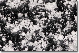
Weather Topic: What is Graupel?
Home - Education - Precipitation - Graupel
 Next Topic: Hail
Graupel is a form of precipitation that is created by atmospheric conditions
which cause supercooled water droplets to contact snow crystals and freeze to
their surface.
Sometimes known as soft hail or snow pellets, graupel is delicate and easily
destroyed by touch. Whereas hail usually falls during severe weather, graupel
doesn't require such conditions to form, and can form in mild precipitation
similar to situations which produce snowfall.
Next Topic: Hail
Current conditions powered by WeatherAPI.com


