Weather Alert in California
Red Flag Warning issued June 29 at 11:21PM PDT until June 30 at 11:00PM PDT by NWS Eureka CA
AREAS AFFECTED: Lower Middle Klamath; Hoopa; Van Duzen/Mad River; W Mendocino NF/E Mendocino Unit; Trinity
DESCRIPTION: ...SCATTERED DRY LIGHTNING IS LIKELY MONDAY AND TUESDAY AFTERNOON ACROSS THE INTERIOR MOUNTAINS... .A pulse of moisture moving up the Central Valley combined with very hot and dry surface conditions and moderate easterly winds will combine to create scattered dry thunderstorms over the interior mountains. Any storms that do form will likely produce wetting rain in the cores but lightning is possible far from these cores in areas that will remain dry. Stroms Monday are most likely over Northern Trinity and Interior Humboldt with moderate movement towards the coast. Stroms Tuesday will be more stationary and are most likely to form over southern Trinity and Northern Mendocino Counties. * THUNDERSTORMS...Scattered dry thunderstorms are likely (25% chance) Monday Tuesday afternoons. There is a slight chance of isolated thundersotrms overnight Monday into Tuesday. * OUTFLOW WINDS...Gusty and erratic outflow winds are possible up to 50 mph. * IMPACTS...any fires that develop will likely spread rapidly. Outdoor burning is not recommended.
INSTRUCTION: A Red Flag Warning means that critical fire weather conditions are either occurring now, or will shortly. A combination of strong winds, low relative humidity, and warm temperatures can contribute to extreme fire behavior. A Fire Weather Watch means that critical fire weather conditions are forecast to occur. Listen for later forecasts and possible Red Flag Warnings.
Want more detail? Get the Complete 7 Day and Night Detailed Forecast!
Current U.S. National Radar--Current
The Current National Weather Radar is shown below with a UTC Time (subtract 5 hours from UTC to get Eastern Time).

National Weather Forecast--Current
The Current National Weather Forecast and National Weather Map are shown below.

National Weather Forecast for Tomorrow
Tomorrow National Weather Forecast and Tomorrow National Weather Map are show below.

North America Water Vapor (Moisture)
This map shows recent moisture content over North America. Bright and colored areas show high moisture (ie, clouds); brown indicates very little moisture present; black indicates no moisture.

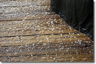
Weather Topic: What is Sleet?
Home - Education - Precipitation - Sleet
 Next Topic: Snow
Sleet is a form of precipitation in which small ice pellets are the primary
components. These ice pellets are smaller and more translucent than hailstones,
and harder than graupel. Sleet is caused by specific atmospheric conditions and
therefore typically doesn't last for extended periods of time.
The condition which leads to sleet formation requires a warmer body of air to be
wedged in between two sub-freezing bodies of air. When snow falls through a warmer
layer of air it melts, and as it falls through the next sub-freezing body of air
it freezes again, forming ice pellets known as sleet. In some cases, water
droplets don't have time to freeze before reaching the surface and the result is
freezing rain.
Next Topic: Snow
Weather Topic: What are Stratocumulus Clouds?
Home - Education - Cloud Types - Stratocumulus Clouds
 Next Topic: Stratus Clouds
Stratocumulus clouds are similar to altocumulus clouds in their
fluffy appearance, but have a slightly darker shade due to their additional mass.
A good way to distinguish the two cloud types is to hold your hand out and measure
the size of an individual cloud; if it is the size of your thumb it is generally
an altocumulus cloud, if it is the size of your hand it is generally a
stratocumulus cloud.
It is uncommon for stratocumulus clouds to produce precipitation, but if they do
it is usually a light rain or snow.
Next Topic: Stratus Clouds
Current conditions powered by WeatherAPI.com


