Weather Alert in Florida
Flood Warning issued August 25 at 9:06PM EDT until August 28 at 2:00PM EDT by NWS Melbourne FL
AREAS AFFECTED: Lake, FL; Volusia, FL
DESCRIPTION: ...The Flood Warning continues for the following rivers in Florida... St Johns River Near Astor affecting Volusia and Lake Counties. .Heavy rain and saturated soils in the Middle Saint Johns basin have led to a steady rise in river levels near Astor. Levels are forecast to slowly rise to Minor Flood Stage within the next day, and remain steady through mid to late week. For the St. Johns River...including Astor...Minor flooding is forecast. Additional information is available at www.weather.gov. The next statement will be issued Tuesday afternoon at noon EDT. * WHAT...Minor flooding is forecast. * WHERE...St Johns River near Astor. * WHEN...From Tuesday morning to early Thursday afternoon. * IMPACTS...At 2.3 feet, Many docks become submerged along the river and in canals in the Astor community. Water enters yards of properties on Bartram Road, Holiday Circle and along Wild Hog Road on the Lake County side. In Volusia County, water encroaches yards of homes on the river side of Alice Drive. No wake zones are in effect from near the South Moon Canal to approximately 800 feet south of the Riverview lodge. * ADDITIONAL DETAILS... - At 8:30 PM EDT Monday the stage was 2.2 feet. - Bankfull stage is 2.0 feet. - Forecast...The river is expected to rise to a crest of 2.3 feet tomorrow morning. It will then fall below flood stage Thursday morning. - Flood stage is 2.3 feet. - http://www.weather.gov/safety/flood
INSTRUCTION: N/A
Want more detail? Get the Complete 7 Day and Night Detailed Forecast!
Current U.S. National Radar--Current
The Current National Weather Radar is shown below with a UTC Time (subtract 5 hours from UTC to get Eastern Time).

National Weather Forecast--Current
The Current National Weather Forecast and National Weather Map are shown below.

National Weather Forecast for Tomorrow
Tomorrow National Weather Forecast and Tomorrow National Weather Map are show below.

North America Water Vapor (Moisture)
This map shows recent moisture content over North America. Bright and colored areas show high moisture (ie, clouds); brown indicates very little moisture present; black indicates no moisture.

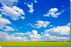
Weather Topic: What are Cumulus Clouds?
Home - Education - Cloud Types - Cumulus Clouds
 Next Topic: Drizzle
Cumulus clouds are fluffy and textured with rounded tops, and
may have flat bottoms. The border of a cumulus cloud
is clearly defined, and can have the appearance of cotton or cauliflower.
Cumulus clouds form at low altitudes (rarely above 2 km) but can grow very tall,
becoming cumulus congestus and possibly the even taller cumulonimbus clouds.
When cumulus clouds become taller, they have a greater chance of producing precipitation.
Next Topic: Drizzle
Weather Topic: What is Evaporation?
Home - Education - Precipitation - Evaporation
 Next Topic: Fog
Evaporation is the process which returns water from the earth
back to the atmosphere, and is another crucial process in the water cycle.
Evaporation is the transformation of liquid into gas, and it happens because
molecules are excited by the application of energy and turn into vapor.
In order for water to evaporate it has to be on the surface of a body of water.
Next Topic: Fog
Current conditions powered by WeatherAPI.com


