Weather Alert in California
Special Weather Statement issued February 11 at 12:57AM PST by NWS Los Angeles/Oxnard CA
AREAS AFFECTED: Los Angeles County Beaches; Los Angeles County Inland Coast including Downtown Los Angeles; Eastern San Fernando Valley; Western San Gabriel Mountains and Highway 14 Corridor; Eastern San Gabriel Mountains; Los Angeles County San Gabriel Valley
DESCRIPTION: At 1256 AM PST, Doppler radar was tracking a line of strong showers extending from near La Canada Flintridge to Pasadena to Alhambra to near Whittier to near Seal Beach to 8 miles south of Long Beach. Movement was east at 15 mph. HAZARD...Wind gusts up to 50 mph. Funnel cloud possible. SOURCE...Radar indicated. IMPACT...Gusty winds could knock down tree limbs and blow around unsecured objects. Locations impacted include... Long Beach...Alhambra...West Covina...Pasadena...Mount Wilson... Whittier...Buena Park...La Habra...Altadena...Los Alamitos... Glendale...La Canada Flintridge...Eagle Rock...Carson...Artesia... Baldwin Park...Commerce...Boyle Heights...and Santa Fe Springs.
INSTRUCTION: If outdoors, consider seeking shelter inside a building. Torrential rainfall is also occurring with these storms and may lead to localized flooding. Do not drive your vehicle through flooded roadways. To report severe weather, contact your nearest law enforcement agency. They will relay your report to the National Weather Service office in OXNARD.
Want more detail? Get the Complete 7 Day and Night Detailed Forecast!
Current U.S. National Radar--Current
The Current National Weather Radar is shown below with a UTC Time (subtract 5 hours from UTC to get Eastern Time).

National Weather Forecast--Current
The Current National Weather Forecast and National Weather Map are shown below.

National Weather Forecast for Tomorrow
Tomorrow National Weather Forecast and Tomorrow National Weather Map are show below.

North America Water Vapor (Moisture)
This map shows recent moisture content over North America. Bright and colored areas show high moisture (ie, clouds); brown indicates very little moisture present; black indicates no moisture.

Weather Topic: What is Condensation?
Home - Education - Precipitation - Condensation
 Next Topic: Contrails
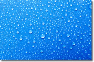
Condensation is the process which creates clouds, and therefore
it is a crucial process in the water cycle.
Condensation is the change of matter from a state of gas into a state of liquid,
and it happens because water molecules release heat into the atmosphere and
become organized into a more closely packed structure, what we might see as
water droplets.
Water is always present in the air around us as a vapor, but it's too small for
us to see. When water undergoes the process of condensation it becomes organized
into visible water droplets. You've probably seen condensation happen before on the
surface of a cold drink!
Next Topic: Contrails
Weather Topic: What are Cumulonimbus Clouds?
Home - Education - Cloud Types - Cumulonimbus Clouds
 Next Topic: Cumulus Clouds
The final form taken by a growing cumulus cloud is the
cumulonimbus cloud, which is very tall and dense.
The tower of a cumulonimbus cloud can soar 23 km into the atmosphere, although
most commonly they stop growing at an altitude of 6 km.
Even small cumulonimbus clouds appear very large in comparison to other cloud types.
They can signal the approach of stormy weather, such as thunderstorms or blizzards.
Next Topic: Cumulus Clouds
Current conditions powered by WeatherAPI.com


